.png)
.svg)


Jasper, Alberta is a beloved gem of the Canadian Rockies. With magical forests, braided rivers, waterfalls, canyons, emerald lakes, and snow-capped mountains, it creates an unforgettable setting for outdoor adventure and family holidays.
Looking to explore the best easy hikes in Jasper, Alberta? Jasper National Park offers gentle trails with incredible views—perfect for families, casual adventurers, and nature lovers alike. From serene lakeside strolls to short forest loops, Jasper’s landscape is calling. Please note: All images were taken before the 2024 Chetamon Wildfire. While this article features current trail info based on the latest Parks Canada updates, be sure to consult their site before heading out as some areas remain closed due to fire recovery efforts.
Easy Hikes in Jasper, Alberta
The best thing about Jasper is that all this natural beauty is accessible to beginner hikers, families with young children and folks of all abilities. If you want to explore some of this world-renowned park on foot, here are our top picks for easy hikes in Jasper, Alberta.
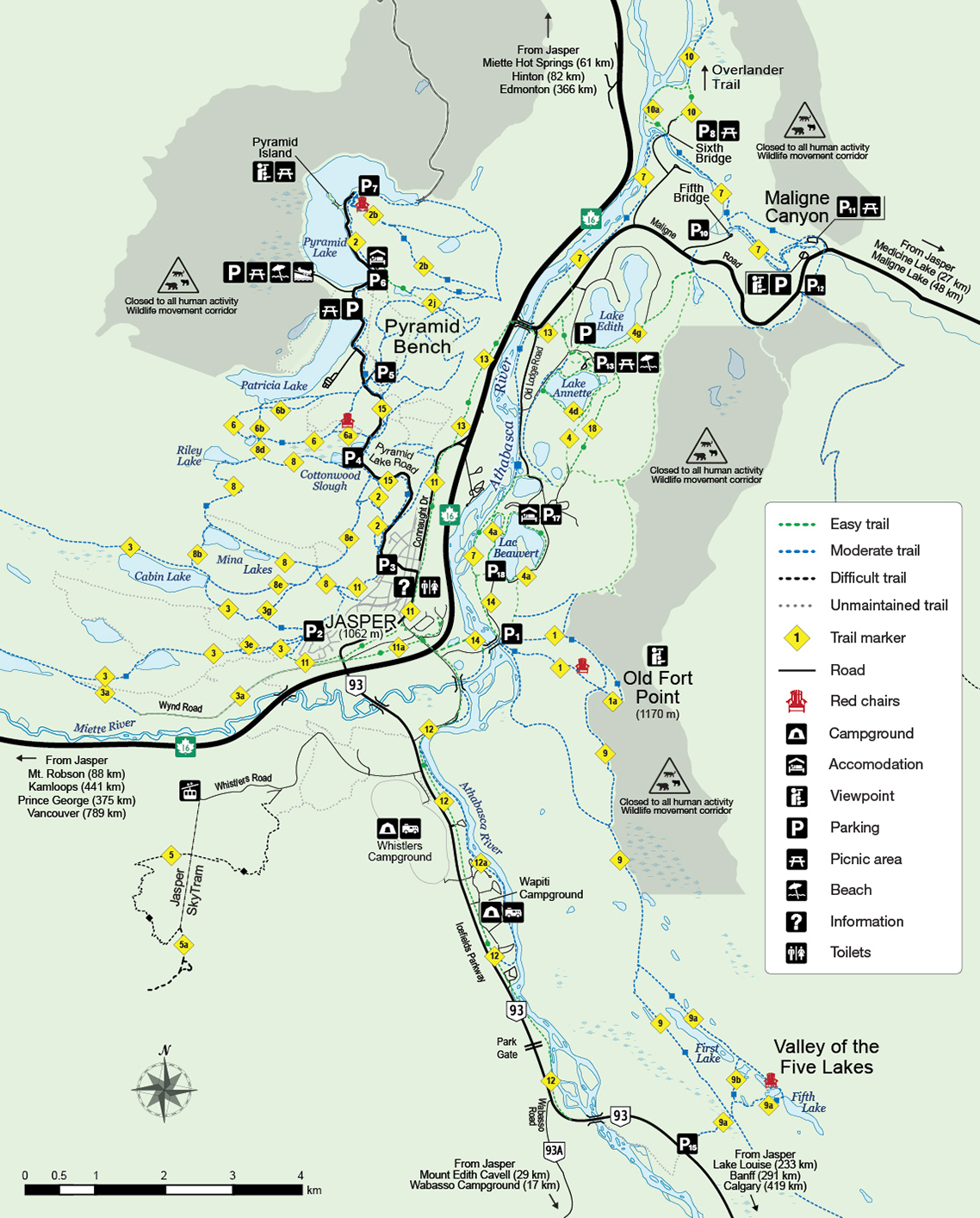
1. Lake Annette Loop
The Lake Annette trail is the shortest, flatest and most accessible hike on our list. Located near the Jasper townsite, it is a favourite spot for picnics, campfires, and beach days. The trail, which is paved and fully accessible, circumnavigates the beautiful blue-green waters of Lake Annette. You’ll get an introduction to one of Jasper’s most famous lakes, and the mountain ranges that create a backdrop behind it. A quaint gazebo offers a bench and rest stop about halfway along the trail and a picnic area with a playground and sandy beach near the main parking lot.

There are a few minor hills on the Lake Annette trail, but it is accessible to wheelchairs and strollers. While it would be a great little cycling route for kids, unfortunately, bikes are prohibited on this trail.
- DISTANCE: Lake Annette hike is 2.4 KM return, with no elevation gain.
- DIFFICULTY: Lake Annette hike loop easy walk on a wheelchair-accessible path. It should take between 30 minutes to 1.5 hours, depending on how many times you stop to take a photo!
- TRAILHEAD: From the Jasper townsite, drive east on Highway 16 for about 2 KM, and turn right on Maligne Road. Take a right at the fork onto Lodge Road, then turn left at the sign for Lake Annette. Keep right at all intersections until you find the main parking lot for the Lake Annette Picnic area. You can go either left or right on the trail along the shore.
2. Path of the Glacier Trail
Stepping onto this short Path of the Glacier trail is like stepping into a different world. The forest gives way to a rocky moonscape as you follow the same path carved out of the Angel and Cavell Glaciers years ago-though Parks Canada has done an excellent job of maintaining it!

While walking through gravel, rocks and boulders, you’ll be walking towards the rising Mt. Edith Cavell and making your way to the viewpoint of both glaciers and an impressive moraine ridge. Once there, you’ll see Cavell Pond with the smaller Cavell Glacier above it. You’ll also see Angel Glacier hanging between Mt. Edith Cavell and Sorrow Peak.
- DISTANCE: Path of the Glacier hike is 1.6 KM return, 70 m elevation.
- DIFFICULTY: This trail starts paved but turns to gravel about a third of the way. It has a few ups and downs and rocks on the trail, so wear a great pair of shoes, like these Columbia hiking boots. It should take you 20 to 30 minutes to reach the viewpoint.
- TRAILHEAD: From the Jasper townsite or Highway 16, follow Highway 93 (Icefields Parkway) south to the Edit Cavell sign. Turn right and follow Edith Cavell Road to the trail parking lot. Please note that this trail is closed in the winter and into the shoulder seasons. Check for Jasper trail conditions and closures before you go.
3. Old Fort Point
The Old Fort Point Loop is an easy hike that will give you the taste of a summit! You’ll climb a protruding bedrock hill that towers 130 metres above the Athabasca River. Most days, you’ll share the part of the summit with a few grazing big-horned sheep. Just remember to give them their space.

A steep but quick climb up a wooden staircase up the cliffside brings you to the top and the big views. If you prefer a more gradual climb, take the path marked Trail 1, which starts near the information kiosk. This easy and wide path through the forest will bring you around to the top of the outcrop without climbing stairs. You will have to go down the stairs on the cliffside or turn around and return through the forest.
On a clear day, the views from the top include sweeping 360-degree vistas of Colin Range, Signal Mountain, the cliffs of Mt Tekarra, Mt. Edith Cavell, Whistlers Mountain, Miette River Valley, Athabasca River Valley, the Victoria Cross Range (featuring red-rocked Pyramid Mountain), and the emerald waters of Lakes Annette, Edith, and Beauvert dotting the valley floor.
- DISTANCE: Oldd Fort Point hike is 3.8 KM return, with 130m elevation gain.
- DIFFICULTY: If you take the stairs first, expect a steep climb up the cliffside of the hill. It’s highly doable with kids, but if climbing isn’t your thing, it’s easier to take the forest path first and the stairs down. Depending on how much time you spend on the top, this should take about 1.5 to 2.5 hours to complete.
- TRAILHEAD: From the Jasper townsite or Highway 16, follow Highway 93A to the Old Fort Point/Lac Beauvert access road sign. You’ll cross the Athabasca River on a bridge, then see the parking lot on the right.
4. Pyramid Bench Trails – Overlook Loop
The Pyramid Bench trail system offers several easy-to-moderate trails, so hikers of all ages and abilities have options when exploring this beautiful part of the park. Our personal favourite for families is the Overlook Loop. This 5.3 km loop showcases high views of the Athabasca, Maligne and Miette river valleys. Plus, there are iconic Parks Canada red chairs where you can enjoy a rest stop along the way.

There are many trails in this system, with some accessible from town, Pyramid Lake, Patricia Lake, and along the Pyramid Lake Road. You can choose your own adventure and create a hike that is as long or as short as your group prefers. View the trail map for more information.
- DISTANCE: 5.3 KM return, with 75m elevation gain.
- DIFFICULTY: The Overlook Loop is rated easy to moderate. There are a few intersections along the trail, so take a photo of the trail system map before heading out so you don’t miss your turn! Plan to spend 2+ hours on this trail. Note: horses use this trail frequently.
- TRAILHEAD: From Jasper, take Pyramid Lake Road to Pyramid Lake. Drive past the resort, Pyramid Island, and park at P7 north on Pyramid Lake Road.
5. Talbot Lake Viewpoint
This is not an official trail or maintained by Parks Canada, but it’s a quick in-and-out hike that gives families remarkable views of Talbot Lake, the braiding Athabasca River, and the surrounding peaks. Starting at a little pull-out parking lot on the north end of Talbot Lake off Highway 16, follow the sandy trails up the grassy knoll. You can see the boot-beaten path from the highway to the top of the hill.

As mentioned, views from the top are exceptional and kiddos will love to jump, climb and play on the rocks and boulders there. Plus, you might catch a glimpse of bighorn sheep as they like to graze on the side of the hill.
- DISTANCE: 1.6 KM return, about 65m elevation gain.
- DIFFICULTY: This trail is easy to moderate, but the walk up the hill is a bit steep. There are also some rocks and boulders at the top, so be sure to wear sturdy footwear.
- TRAILHEAD: From Jasper, take Highway 16 (Yellowhead) east about 28km. Turn right into the little parking lot on the north end of Talbot Lake.
6. Maligne Canyon
Maligne Canyon is a must-see when visiting Jasper National Park. At the time of writing, Maligne Canyon is still closed for wildfire cleanup and restoration, so please check trail conditions and closures before you go. We hope it opens soon!

This famous limestone gorge features views of waterfalls (frozen in the winter) and the smooth, unique rock formations of the canyon. The best views of the canyon are from Trail 7, accessible via the Fifth Bridge trailhead. This way, you’re walking up-canyon to see the water gushing towards you and get a better view of the steep limestone walls.
If you keep right at the Second Bridge, you’ll leave Trail 7 and follow a short path to the hike’s most spectacular waterfall. Then, you can loop back before getting to the main parking lot and enjoy the views down-canyon, too!
If you’re visiting Maligne Canyon in the winter, consider booking a Maligne Canyon Icewalk Tour. You’ll be outfitted with microspikes for your boots and a helmet before heading out on a guided tour of the frozen river, waterfalls and canyon. Experiencing the canyon from its frozen floor is unforgettable, and for your safety, should only be done with a professional guide. Otherwise, it’s best to stick to the maintained trail.
- DISTANCE: 2.1 km, one way from Fifth Bridge. Minimal elevation gain.
- DIFFICULTY: This is an easy hike along wide gravel pathways and wooden bridges with few inclines. Expect to spend 1.5 to 2.5 hours exploring here. A few sections have wood stairs that can get slippery in the winter, so take precautions.
- TRAILHEAD: From the Jasper townsite, drive east on Highway 16 for about 2 KM and turn right on Maligne Road. At the fork, take a left onto Maligne Road and look for signs for Fifth Bridge. Turn right to find the parking lot and trailhead.
Before you go…
While planning your trip, check out what’s open in Jasper National Park. Some areas impacted by the wildfire remain unsafe for visitors and are closed. You can also check out what businesses are open in the Town of Jasper. That listing includes restaurants, cafes, places to stay, stores, services, and community spaces.
Please be mindful of road closures and signs while in town and the park, avoid recovery areas, and only visit areas open to the public.
Aren't we lucky to be able to access such amazing hikes near Jasper, Alberta! That said, we must always be mindful of adventuring our beautiful backyard, responsibly.
To ensure that your visit is sustainable, consider these tips:
- Plan: Prepare in advance to minimize the impacts of your visit. Check current weather and trail conditions at location where you're travelling.
- Keep it natural: Leave what you find, and take what you bring. Don't damage plants - observe our beautiful landscape without altering it.
- Take your trash with you: Always carry a reusable bag to dispose of your litter and recyclables properly. Don't throw food waste away - it attracts wildlife.
- Respect the wildlife: The Canadian Rockies are home to a diverse range of wildlife, from bears to elk to bighorn sheep. But always remember to keep a respectful distance and never feed them, as this can disrupt their natural behaviours and make them a danger to humans and vehicles.
- Carpool: Whenever possible, carpool with your fellow adventurers to offset carbon emissions and parking spaces at trailheads.
- Use public transportation: Use eco-friendly modes of transportation such as buses, which are readily available in the Rockies.
- Support local: Engage in activities such as sports equipment rental, local restaurants and markets, and cultural events such as museums and shows.
- Choose sustainable accommodation: Look for eco-friendly hotels, lodges, or campsites that promote sustainable tourism practices.
- Communication: Often overlooked as a sustainable measure, communicating with someone on your travel plans is key as it may minimize the use of emergency services, or aid for a quicker response in emergency settings.
- Always be prepared: The Canadian Rockies are rugged and isolated. Carry enough food, water, clothing, maps, and other essentials such as bear spray and a first aid kit.


